East Albany Plan Adoption
The East Albany Plan provided an opportunity to take a fresh look at land within the city’s Urban Growth Boundary east of Interstate 5 and create a new plan focused on connectivity, transportation choices, housing variety, employment centers, and vibrant and walkable mixed-use areas, while protecting the area’s natural resources and viewsheds.
The East Albany Plan is a long-range guiding document that will help the city plan for future residential, employment, commercial growth and associated utility, facility, and transportation needs.
Adopted Documents
The City Council adopted the East Albany Plan and associated amendments to the Albany Comprehensive Plan and map, the Zoning map, and Albany Development Code on May 10, 2023. The amendments go into effect July 1, 2023.
Ordinance 6010 with exhibits
Individual exhibits are below:
Overview
Project Overview – Why this Plan?
East Albany represents a key growth area for the City, with a large land base that represents much of the community's future growth and expansion. Since the 2001 "East I-5 Plan" was prepared, the area has seen housing growth, as well as development of larger commercial businesses and light industrial facilities. However, development of neighborhood commercial services and creation of an integrated transportation, parks and trails system has lagged. It's time to take a fresh look at this key growth area for the City and create a new plan focused on connectivity, transportation choices, housing variety, and vibrant mixed-use and employment centers around the area’s natural resources and viewsheds.
This project is funded through a grant from the State of Oregon's Transportation and Growth Management (TGM) program, a partnership between ODOT and the Department of Land Conservation and Development (DLCD). The City of Albany has hired a multi-disciplinary team of consultants to assist with this effort, including APG, Walker Macy, Johnson Economics, DKS Associates, and Keller Associates.
Area
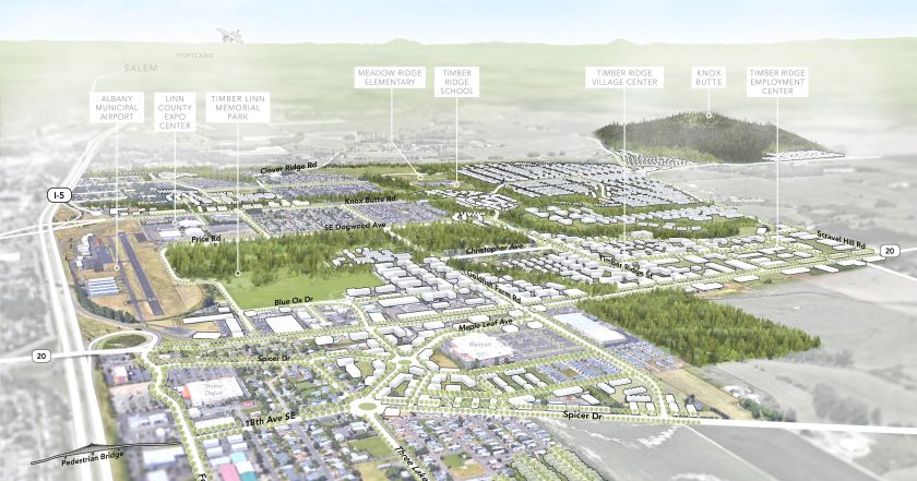
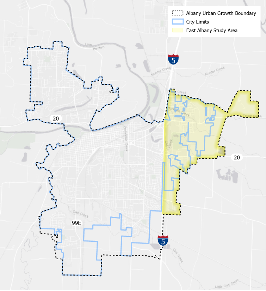
This project will address the area shown in the map below. This land is within the Albany Urban Growth Boundary east of I-5 and totals about 2,800 acres. The City’s largest park, Timber Linn Park, and the Linn County Fair and Expo Center are located in the western portion of the Study Area near I-5. Most commercial development in East Albany is along US 20 or near I-5 and has a regional draw (Walmart, Home Depot, car sales) or caters to travelers. A collection of properties zoned Regional Commercial adjacent to the Knox Butte interchange remain underdeveloped with low-density residential uses. Recent development has included both traditional residential neighborhoods with single-family homes, as well as more recent development of apartments.
Conditions and Challenges
East Albany faces several significant transportation challenges, including travel generated by regional destinations in the area, connectivity issues, the need for direct access to properties near I-5, limited pedestrian and bicycle facilities, and traffic expected from future housing development.
A variety of tools will be evaluated and potentially implemented to help address these issues, including an emphasis on mixed-use development and complete communities to reduce vehicle trips, development of a robust bicycle and pedestrian network, event traffic management strategies, and relevant direction from previous planning efforts, including the Regional Transportation Plan, Transit Development Plan, and ADA Transition Plan.
East Albany contains several streams and wetlands which can be desirable amenities for future residents when incorporated into a network of trails and natural areas. However, these features can also be challenging for the creation of well-connected transportation and infrastructure systems.
Scope and Schedule
Plan Scope and Schedule
The East Albany Plan aims to:
- Connect residential, employment, commercial, and recreational uses with a functional and safe multi-modal transportation system and interconnected greenway trail system.
- Create transportation system that provides access and mobility while supporting anticipated residential and employment growth.
- Create attractive gateways into Albany from I-5 and US 20.
- Increase the variety of housing types, densities, and mixed-use developments to accommodate the needs of current and future residents.
- Protect the area’s riparian and wildlife corridors, wetlands, and drainage ways located within significant natural resource overlays.
- Use interconnected natural resource corridors to provide pedestrian, open space, and wildlife connectivity between neighborhoods and help protect scenic vistas.
- Identify opportunities to provide aesthetic and recreational amenities.
- Identify a strategy for implementation, including short-term and long-term measures the City can take that will help achieve its goals for East Albany.
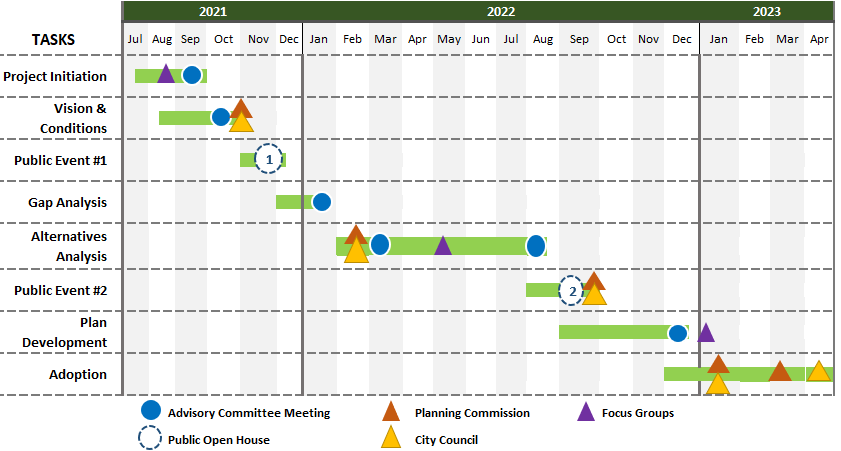
The anticipated project schedule is shown here represents the team’s goals for completing key milestones in the planning process. It is subject to change, in the event that unforeseen circumstances cause project delays or necessitate course corrections. The project has several distinct phases:
- Project Initiation - Summer 2021. This kickoff task includes establishing the project's advisory committees, project informational materials, and early stakeholder outreach.
- Vision and Conditions for East Albany - Fall 2021. This step will detail the existing conditions in East Albany and establish the project's guiding vision and objectives.
- Public Event #1 - Winter 2021. This is the first major touchstone with the broader community for this process. Public Event 1 will focus on the community's vision for East Albany and will inform later steps in the process.
- Gap Analysis - Winter 2021/2022. This step will take a close look at gaps in the transportation system, missing housing opportunities, and the challenges to and benefits of creating an interconnected system of parks, trails and natural areas.
- Scenario Development and Analysis - Winter/Spring 2022. This step will create alternatives for land uses and the transportation system in East Albany and analysis of how well these alternatives meet the project's goals.
- Public Event 2 - ummer 2022. This is the second major touchstone with the broader community, focusing on the plan alternatives developed in Step 5. Community input will help craft a preferred alternative for East Albany.
- Plan Development and Implementation - Fall 2022. This step will include developing the plan and will address needed amendments to the City's Comprehensive Plan and Development Code, infrastructure needs, and a funding plan in order to implement the preferred alternative.
- Adoption - Fall 2022/Winter 2023. This step will include plan adoption hearings of the Albany Planning Commission and City Council.
Engagement
Community Engagement
How can you get involved?
Public events
October 6, 2022
At Linn County Fair & Expo Conference Center.
October 2022
Online Open House Survey
June/July 2022
At City Hall
May 31, 2022
Community Conversations event at Cascade Grill.
November/December 2021
The first public event is was an online open house in November and December of 2021. View the event summary here.
Focus groups
Residents, property owners, businesses, and community leaders will participate in three focus groups at key project milestones. See Focus Group Summaries on the Project Documents Tab.
Project Advisory Committee (PAC)
The PAC’s role is to review all project deliverables and community input and provide guidance to the city and consultants. The PAC includes businesses, residents, and property owners in the study area, Greater Albany Public Schools, Albany Bike/Pedestrian Committee, Cascades West Council of Governments, Oregon Department of Transportation, Linn County, and City public works and parks and recreation departments. Six PAC meetings are scheduled throughout the various phases of the project. The PAC roster and meeting materials are listed below.
Planning Commission / City Council Work Sessions
The Albany Planning Commission and City Council will hold four joint work sessions throughout the project to review project deliverables and community input and provide input throughout the project. Meeting materials, minutes, and audio can be found on the Planning Commission website.
Written feedback
You can provide written feedback anytime by emailing
East Albany Plan Project Advisory Committee
This project will be guided by a Project Advisory Committee (PAC), which will meet regularly to review project materials.
Members
No vacancies? No problem. You can still put your application on file.
There are no documents available for this group in 2026.
Public Meetings Law Grievances
OAR 199-050-0070 requires us to publish contact information for submitting a grievance alleging violation of the Oregon public meetings laws. Written grievances may be submitted by email to
Documents
Project Documents
Project documents and other materials will be available on this page. The most recent materials are at the top of the list.
- Preferred Land Use Plan
- Streets Plan
- Trails, Paths and Bike Lanes Plan
- Transportation Analysis and TSP Amendments
- Infrastructure Analysis
- East Albany Transportation Evaluation Memo
- PAC 8-30-2022 Meeting Slides: Analysis of Scenarios
- Development Scenarios Report 8-24-2022
- Transportation Gap Analysis 1-20-2022
- Revised Vision and Goals
- Public Focus Groups Round 1 Summary
- Open House #1 Summary
- Market Analysis 9-29-2021
- GAP Analysis Report 1-20-2022
- Existing Conditions Presentation 10-11-2021
Contact
Questions? Contact us!
If you would like to be added to our interested parties email list to receive periodic updates about the project, sign up under the Community Engagement tab.
If you have other questions or want more information about the project, please contact the City’s lead planner and project manager for this effort, Anne Catlin at 541-917-7560 or

